
Hangerqiaok Fm
Type Locality and Naming
Kuruktag region. The Hangerqiaok Fm was first named as the Hangerqiaok System by Zhu Chengshun et al., in 1958. The typical section is situated in the Hangerqiaok Mountain in middle Kuruktag in Xinjiang. The reference section is in south Yulegunburak in Shanshan County of Xinjiang Weiwuerzhu Zizhiqu (Xinjiang Uygur Autonomous Region) (east Kuruktag). Uppermost formation of the Kuruktag Gr (9 of 9).
The measured profile is located at No. XIV (E88°18′00″; N41°29′20″) Zhaobishan, Zhongkuluktag, Yuli County, Xinjiang, and was re-measured in 1977 by Gao Zhenjia and Zhu Chengshun.
Synonym: (汉格尔乔克组)
Lithology and Thickness
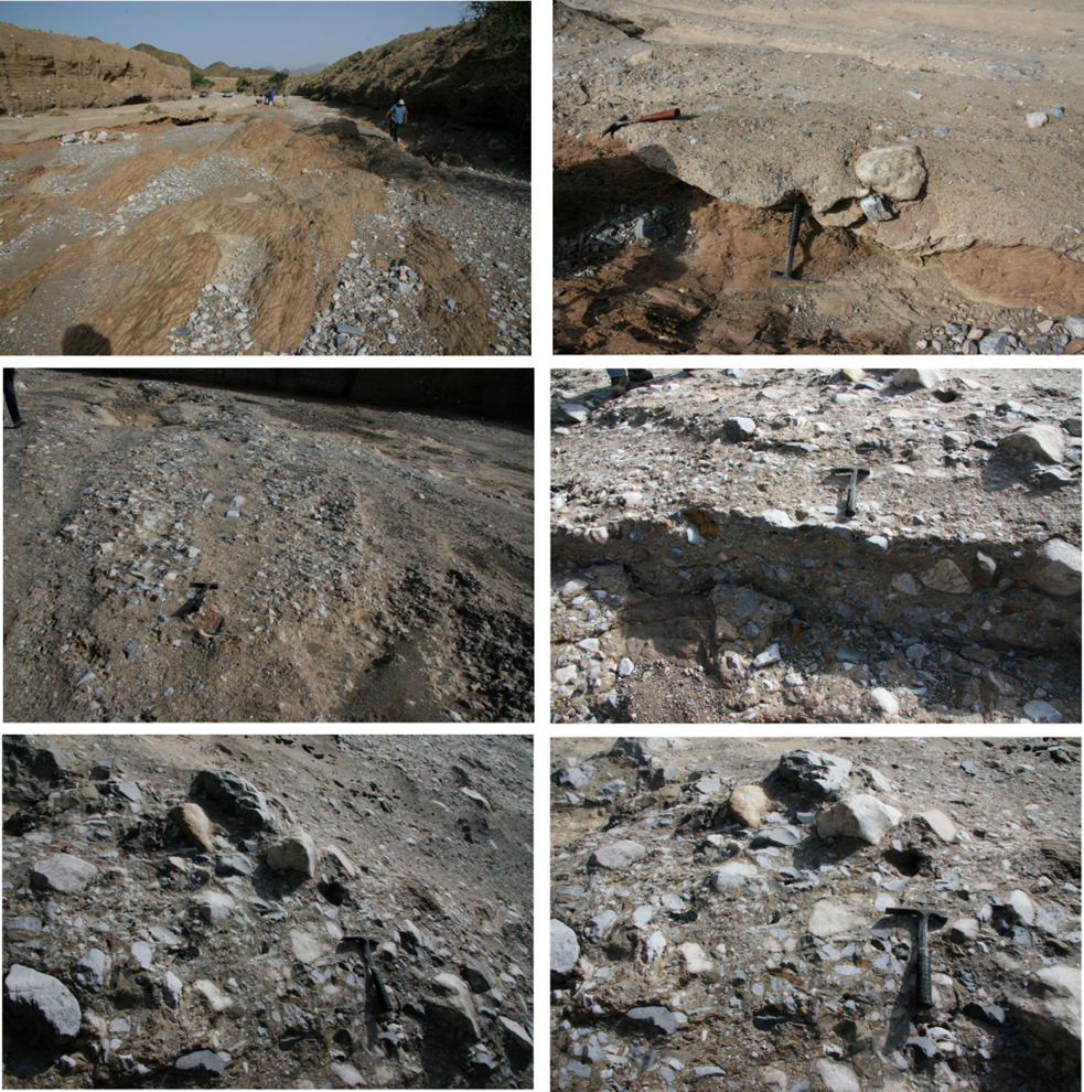
The Hangerqiaok Fm is dominated by gray, dark gray and greenish gray thick-bedded massive diamictite (boulder clay, conglomerate, pebbly mudstone), occasionally intercalated with unstable lenses of sandstone and limestone, and the cement is pelitic or occasionally carbonaceous. The top commonly bears a bed of light greenish gray thin-bedded pebbly varvite or lamellar pebbly dolomite, of which the pebbles generally show "dropstone" feature. With a persistent lithology, the thickness generally varies from 150 to 430 m.
[Figure: Outcrop photos of Hangerqiaok Fm]
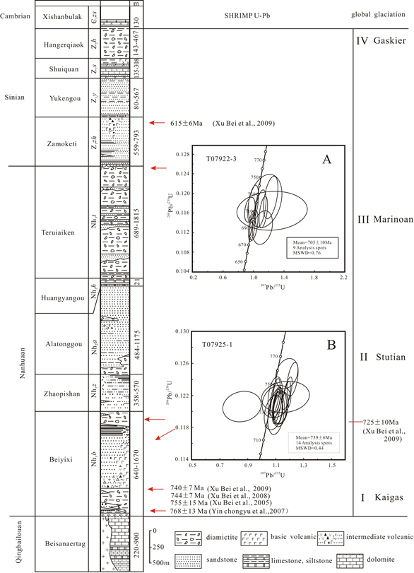
[Figure: Stratigraphic Column of the Kuruktag Gr]
Relationships and Distribution
Lower contact
The lower part of the Hangerqiaok Fm rests disconformably or unconformably on the upper Sinian Shuiquan Fm
Upper contact
The upper part is disconformably overlain by the Xishanbulak Fm (Lower Cambrian).
Regional extent
Kuruktag region. The Hangerqiaok Fm is widely distributed in Kuruktag Mountain area from Xishankou and Moqinkuduk west of Korla on the west, southward to Xingditag in Yuli County, then to Yardang Mountain area, and eastward to Yulegunbulak south of Shanshan County.
GeoJSON
Fossils
The cement of diamictite and varvite contains microplants, represented by Trachysphaeridium rude, T. cultum, Hubeisphaera radiata, Polyporata sp., Pseudozonosphaera sp., Asperatopsophosphaera sp., Trematosphaeridium sp., Monotrematosphaeridium sp., Quadratimorpha sp., etc.
Age
Depositional setting
Additional Information
Paleomagnetic study implied that the strata were deposited at 15.0 to 15.3 north paleolatitude, the paleomagnetic north pole is 97.3 λ, 32.7 ψ and the paleomagnetic south pole is -144.6 λ, -17.19 ψ (Li Yong'an, 1984).
Zhang Yan, Wang Pujun, Liu Wanzhu, & Li Jinlong. (2006). Sedimentary environment and significance of Sinian moraine rocks in Kuluketag area. Xinjiang Geology.